Nowadays, static satellite observations are widely used in many fields. To obtain high measurement accuracy, the static satellite observations of the geodetic network have been carried out using one and two base stations. This study is important due to the lack of information on whether using several base stations impacts measurement accuracy. In addition, the dependence of the measurement accuracy of different lengths of the geodetic network lines on the observation time is investigated. Direct measurements have been carried out on the territory of Egypt, where the development of a geodetic network of the National Agricultural Cadastral Network (NACN) is a burning issue. The observations were conducted using Trimble R10 dual-frequency receivers based on specific schemes. In the case of using one base station, all the lines that connect the nearest points to the station were calculated. In the case where two stations were being used, the observations were carried out simultaneously on three points, including the base points. The third point is the closest point to the baseline. The other three points were determined as follows: two points had been taken from the previous triangle; and the one that was the nearest one to the line formed by the first two points, etc. The analysis of the results shows that if only one station is used, it takes at least 3–4 hours to make measurements that are precise up to a centimeter. The use of two base stations can reduce measurement time by two hours. Additionally, these studies can help select satellite positioning technology based on the equipment available.
| Published in | American Journal of Remote Sensing (Volume 12, Issue 1) |
| DOI | 10.11648/j.ajrs.20241201.13 |
| Page(s) | 18-23 |
| Creative Commons |
This is an Open Access article, distributed under the terms of the Creative Commons Attribution 4.0 International License (http://creativecommons.org/licenses/by/4.0/), which permits unrestricted use, distribution and reproduction in any medium or format, provided the original work is properly cited. |
| Copyright |
Copyright © The Author(s), 2024. Published by Science Publishing Group |
Base Station, Line Determination, Observing Session Duration, RMS Measurement Error, Static Observations
Paths line | Line length (km) | Root-Mean-Square error (mm) at observation time, hours | |||||||||||
|---|---|---|---|---|---|---|---|---|---|---|---|---|---|
1 | 2 | 3 | 4 | 5 | 6 | 7 | 8 | 9 | 10 | 11 | 12 | ||
Case of Using One base station | |||||||||||||
S1 | 17.60 | 40.0 | 28.0 | 14.0 | 12.0 | 11.0 | 9.0 | 9.0 | 9.0 | 8.0 | 7.0 | 8.0 | 6.0 |
S2 | 19.80 | 42.0 | 29.0 | 15.0 | 13.0 | 12.0 | 12.0 | 11.0 | 10.0 | 11.0 | 9.0 | 8.0 | 6.0 |
S3 | 68.7 | 59.0 | 48.0 | 16.0 | 14.0 | 13.0 | 13.0 | 12.0 | 11.0 | 11.0 | 10.0 | 9.0 | 7.0 |
S4 | 26.50 | 45.0 | 32.0 | 15.0 | 13.0 | 12.0 | 12.0 | 11.0 | 10.0 | 10.0 | 8.0 | 6.0 | 6.0 |
S5 | 70.90 | 67.0 | 45.0 | 16.0 | 15.0 | 13.0 | 13.0 | 12.0 | 10.0 | 10.0 | 9.0 | 8.0 | 7.0 |
S6 | 71.50 | 69.0 | 47.0 | 17.0 | 15.0 | 14.0 | 14.0 | 13.0 | 12.0 | 11.0 | 9.0 | 9.0 | 8.0 |
Case of Using Two base stations | |||||||||||||
S1 | 17.60 | 25.0 | 12.0 | 9.0 | 8.0 | 6.0 | 5.0 | 5.0 | 4.0 | 6.0 | 5.0 | 4.0 | 4.0 |
S2 | 19.80 | 27.0 | 13.0 | 10.0 | 9.0 | 8.0 | 6.0 | 6.0 | 5.0 | 7.0 | 6.0 | 5.0 | 5.0 |
S3 | 68.7 | 32.0 | 15 | 11.0 | 10.0 | 11.0 | 11.0 | 9.0 | 8.0 | 9.0 | 6.0 | 4.0 | 4.0 |
S4 | 26.50 | 28.0 | 14.0 | 10.0 | 6.0 | 7.0 | 7.0 | 5.0 | 4.0 | 5.0 | 3.0 | 4.0 | 4.0 |
S5 | 70.90 | 37.0 | 16.0 | 13.0 | 12.0 | 13.0 | 13.0 | 10.0 | 9.0 | 10.0 | 7.0 | 5.0 | 5.0 |
S6 | 71.50 | 42.0 | 16.0 | 14.0 | 13.0 | 14.0 | 13.0 | 12.0 | 11.0 | 9.0 | 9.0 | 7.0 | 5.0 |
NACN | National Agricultural Cadastral Network |
GNSS | Global Navigation Satellite System |
GPS | Global Positioning System |
RMS | Root-Mean-Square |
NGS | National Geodetic Survey |
IGS | International Geodetic Survey |
CORS | Continuously Operating Reference Station |
DOP | Dilution of Precision |
| [1] | Anonymous, 2016, GPS, |
| [2] | Grewal, M. S., Weill, L. R., Andrews, A. P. Global Positioning Systems. Inertial Navigation, and Integration, Wiley, 2007. |
| [3] | Alkan, R. M., İlçi, V., Ozulu, M. PPP Yönteminde GPS and GLONASS. Uydularının Kullanımının Nokta Konum Doğruluğuna Etkisinin Araştırılması, Harita Teknolojileri Elektronik Dergisi, 2014, 6 (2), 27-34.(In Turkish) |
| [4] | Sümeyra, G., Ekrem, T. The Analysis of GPS Data in Different Observation Periods Using Online GNSS Process Services. International Journal of Environment and Geoinformatics (IJEGEO). 2017, Vol: 4 Issue: 1 January. |
| [5] | El-Rabbany, A. Introduction to GPS, the Global Positioning System. Artech House, USA, 2002. |
| [6] | Schofield, W., Breach, M. Engineering Surveying. Elsevier, UK, 2007. |
| [7] | Davis, J. L., Prescot, W. H., Svarc, J., Wendt, K. Assessment of Global Positioning Measurements for Studies of Crustal Deformation.” Journal of Geophysical Research, 1989, 94: 13635-13650. |
| [8] | Dong, D. N., Bock, Y. Global Positioning System Network Analysis with Phase Ambiguity Resolution Applied to Crustal Deformation Studies in California. Journal of Geophysical Research, 1989, 94: 3949-3966. |
| [9] | Larson, K. M., Agnew, D. C. Application of the Global Positioning System to Crustal Deformation Measurement, 1, Precision and Accuracy. Journal of Geophysical Research, 1989, 96: 16547-16565. |
| [10] | Heflin, M. B., Bertiger, W. I., Blewitt, G., Freedman, A. P., Hurst, K. J., Lichten, S. M., Lindqwister, U. J. Vigue, Y., Webb, F. H., Yunck, T. P., Zumberge, J. F. Global Geodesy using GPS without Fiducial Sites. Geophysical Research Letters, 1992, 19: 131-134. |
| [11] | Feigl, K. L., Agnew, D. C., Bock, Y., Dong, D., Donellan, A., Hager, B. H., Herring, T. A., Jakson, D. D., Jordan, T. H., King, R. W., Larsen, S., Larson, K. M., Murray, M. H., Shen, Z. K., Webb, F. H. Space Geodetic Measurement of Crustal Deformation in Central and Southern California, 1984-1992, 1993. Journal of Geophysical Research, 98: 21677-21712. |
| [12] | Rius, A., Juan, J. M., Hernández-Pajares, M., Madrigal, A. M. Measuring Geocentric Radial Coordinates with a Non-Fiducial GPS Network. Bulletin Géodésique, 1995, 69: 320-328. |
| [13] | Eckl, M. C., Snay, R. A., Soler, T., Cline, M. W., Mader, G. L. Accuracy of GPS-Derived Relative Positions as a Function of Inter-Station Distance and Observing-Session Duration. Journal of Geodesy, 2001, 75: 633-640. |
| [14] | Sanli, D. U., Engin, C. Accuracy of GPS Positioning over Regional Scales. Survey Review, 2009, 41: 192-200. |
| [15] | Sanli, D. U., Tekic, S. Accuracy of GPS Precise Point Positioning: A Tool for GPS Accuracy Prediction. Saarbrücken: LAP Lambert Academic Publishing, 2010. |
| [16] | Bertiger, W., Desai, S. D., Haines, B., Harvey, N., Moore, A. W., Owen, S., Weiss, J. P. Single Receiver Phase Ambiguity Resolution with GPS Data. Journal of Geodesy, 2010, 84: 327–337. |
| [17] | Firuzabadi, D., King, R. W. GPS Precision as a Function of Session Duration and Reference Frame using Multi-Point Software. GPS Solutions, 2012, 16: 191–196. |
| [18] | Shamal, F. A., Ramazan, A. A. Effect of Different Network Geometry on GNSS Results. Journal of Selcuk-Technic, 2018, Volume 17, Number: 1-2018. |
| [19] | Udovichenko, N. M., Grishko, N. M. Analysis of the Influence of the Duration of Satellite Observations on the Determination of the Points Coordinates. Vestn. Permskogo nacional'nogo issledovatel'skogo politekhn. un-ta. Geologiya, neftegazovoe i gornoe delo Perm. Vestnik Perm national research polytechnic. University of Geology, Oil and Gas and Mining, 2007, 6 (2): 66–71. [In Russian]. |
| [20] | Antonovich, K. M., Dolganov, I. M. On the Influence of the Duration of the Observation Session on the Accuracy of Determining of the Baseline Components. Vestn. Sibirskogo gosudarstvennogo un-ta geosistem i tekhnologiy. Vestnik SGGA. 2003, (8): 14–18. [In Russian] |
| [21] | Ghoddousi-Fard, R., Dare, P. Online GPS Processing Services: an initial study, GPS Solutions, 2006, 10 (1), 12-20. |
APA Style
Younes, S. A. M. (2024). Assessing the Results of Satellite Positioning for Geodetic Network Points with Different Observation Sessions. American Journal of Remote Sensing, 12(1), 18-23. https://doi.org/10.11648/j.ajrs.20241201.13
ACS Style
Younes, S. A. M. Assessing the Results of Satellite Positioning for Geodetic Network Points with Different Observation Sessions. Am. J. Remote Sens. 2024, 12(1), 18-23. doi: 10.11648/j.ajrs.20241201.13
AMA Style
Younes SAM. Assessing the Results of Satellite Positioning for Geodetic Network Points with Different Observation Sessions. Am J Remote Sens. 2024;12(1):18-23. doi: 10.11648/j.ajrs.20241201.13
@article{10.11648/j.ajrs.20241201.13,
  author = {Sobhy Abdel Monam Younes},
  title = {Assessing the Results of Satellite Positioning for Geodetic Network Points with Different Observation Sessions
},
  journal = {American Journal of Remote Sensing},
  volume = {12},
  number = {1},
  pages = {18-23},
  doi = {10.11648/j.ajrs.20241201.13},
  url = {https://doi.org/10.11648/j.ajrs.20241201.13},
  eprint = {https://article.sciencepublishinggroup.com/pdf/10.11648.j.ajrs.20241201.13},
  abstract = {Nowadays, static satellite observations are widely used in many fields. To obtain high measurement accuracy, the static satellite observations of the geodetic network have been carried out using one and two base stations. This study is important due to the lack of information on whether using several base stations impacts measurement accuracy. In addition, the dependence of the measurement accuracy of different lengths of the geodetic network lines on the observation time is investigated. Direct measurements have been carried out on the territory of Egypt, where the development of a geodetic network of the National Agricultural Cadastral Network (NACN) is a burning issue. The observations were conducted using Trimble R10 dual-frequency receivers based on specific schemes. In the case of using one base station, all the lines that connect the nearest points to the station were calculated. In the case where two stations were being used, the observations were carried out simultaneously on three points, including the base points. The third point is the closest point to the baseline. The other three points were determined as follows: two points had been taken from the previous triangle; and the one that was the nearest one to the line formed by the first two points, etc. The analysis of the results shows that if only one station is used, it takes at least 3–4 hours to make measurements that are precise up to a centimeter. The use of two base stations can reduce measurement time by two hours. Additionally, these studies can help select satellite positioning technology based on the equipment available.
},
 year = {2024}
}
TY  - JOUR
T1  - Assessing the Results of Satellite Positioning for Geodetic Network Points with Different Observation Sessions

AU  - Sobhy Abdel Monam Younes
Y1  - 2024/05/30
PY  - 2024
N1  - https://doi.org/10.11648/j.ajrs.20241201.13
DO  - 10.11648/j.ajrs.20241201.13
T2  - American Journal of Remote Sensing
JF  - American Journal of Remote Sensing
JO  - American Journal of Remote Sensing
SP  - 18
EP  - 23
PB  - Science Publishing Group
SN  - 2328-580X
UR  - https://doi.org/10.11648/j.ajrs.20241201.13
AB  - Nowadays, static satellite observations are widely used in many fields. To obtain high measurement accuracy, the static satellite observations of the geodetic network have been carried out using one and two base stations. This study is important due to the lack of information on whether using several base stations impacts measurement accuracy. In addition, the dependence of the measurement accuracy of different lengths of the geodetic network lines on the observation time is investigated. Direct measurements have been carried out on the territory of Egypt, where the development of a geodetic network of the National Agricultural Cadastral Network (NACN) is a burning issue. The observations were conducted using Trimble R10 dual-frequency receivers based on specific schemes. In the case of using one base station, all the lines that connect the nearest points to the station were calculated. In the case where two stations were being used, the observations were carried out simultaneously on three points, including the base points. The third point is the closest point to the baseline. The other three points were determined as follows: two points had been taken from the previous triangle; and the one that was the nearest one to the line formed by the first two points, etc. The analysis of the results shows that if only one station is used, it takes at least 3–4 hours to make measurements that are precise up to a centimeter. The use of two base stations can reduce measurement time by two hours. Additionally, these studies can help select satellite positioning technology based on the equipment available.

VL  - 12
IS  - 1
ER  -
Public Works Engineering Department, Faculty of Engineering, Tanta University, Tanta City, Egypt; Higher Future Institute of Engineering and Technology in Mansoura, Mansoura City, Egypt
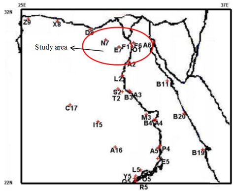
Figure 1. Data points used in the research.
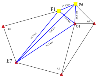
Figure 2. Used geodetic network.
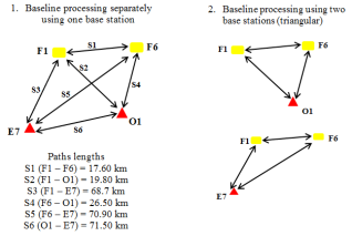
Figure 3. Different measurement paths.
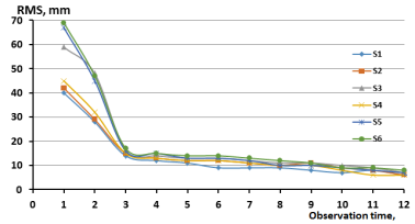
Figure 4. The Root Mean Square errors in determining line lengths for the case of using one base station.
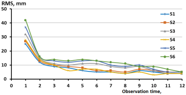
Figure 5. The Root Mean Square errors in determining line lengths for the case of using two base stations.
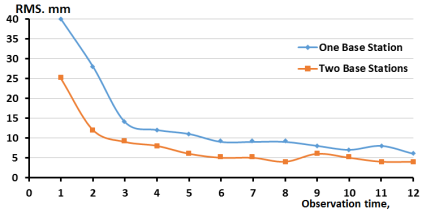
Figure 6. RMS error variances of observations using one or two base stations.